Eddie’s weather blog | Wednesday, December 18, 2024
POST 3 | 6:19 PM NST (5:49 PM AST)
Special Weather Statement(s) issued for Saturday into Sunday, and they read as follows:
For the Island:
Current details:
Adverse weather is expected for Newfoundland this weekend, consisting of:
1) Mostly rain in the east,
2) Mostly snow in the north,
3) Wintry mix elsewhere,
4) Strong winds all locations.
Time span: from early Saturday into Sunday.
Remarks: An approaching weather system will bring strong winds and various forms of precipitation to island on Saturday. Mostly rain is expected over southern and eastern areas, with mainly snow in the north. Elsewhere, precipitation is expected to begin as snow before transitioning through a mixture of ice pellets and freezing rain to rain over the course of the day. Significant amounts of freezing precipitation may occur over some sections of the interior.
Anyone planning travel should be prepared for adverse weather conditions. Conditions will improve for most areas on Sunday, though onshore flurries and local snow squalls will develop over western parts of the island as temperatures turn colder.

For Labrador:
Current details:
Snow, strong winds, and blowing snow expected this weekend.
Locations: southeastern Labrador.
Time span: from midday Saturday into Sunday.
Remarks: While it is too soon to forecast accumulations, the potential exists for significant snowfall over some areas. Strong winds accompanying the snow will result in poor visibility in blowing snow.
Anyone planning travel this weekend should be prepared for adverse winter weather. Conditions are expected to improve again late Sunday into Monday.
POST 2 | 11:28 AM NST (10:58 AM AST)
The weather is improving across the Province as a cold front has moved offshore. Sunshine will become more prevalent across the Island. The weather in the Big Land is improving as well compared to yesterday. Satellite imagery shows this rather well.

POST 1 | 6:03 AM NST (5:33 AM AST)
Our Wednesday morning is starting off on the soggy side for the eastern areas of the Island, where an area of rain is in the process of moving offshore. The radar loop (below) shows this rather well. Within the next half hour, the rain will have left the east coast of Avalon.
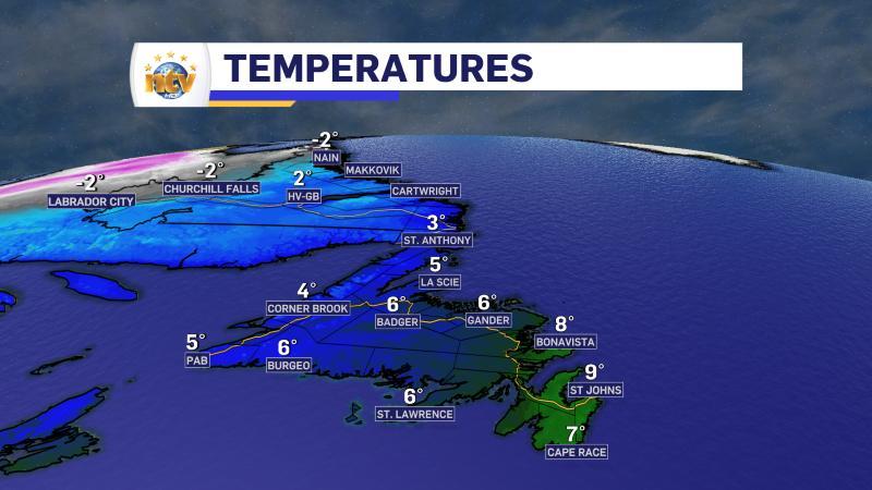
We are also looking at generally mild temperatures across the Province this morning, with many areas of the Island reporting readings between 3º and 9º; Labrador is hovering in the single digits below freezing to this point.
Today will see the weather on the Island improving, meaning a mix of sun and cloud. The exception will be along the West Coast where showers (low elevations) and flurries (high elevations) will be present. Some flurries will also fly in parts of Labrador.
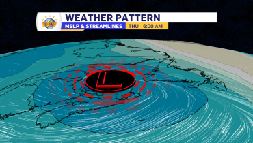
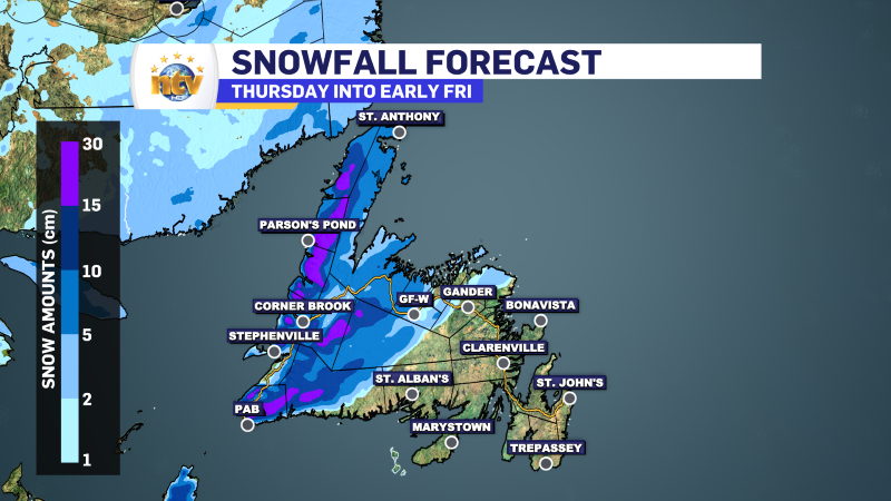
Our next weather maker moves in tomorrow and promises to bring some rain and snow to the Island. Check back for more updates on this later today.
Related Articles