Eddie’s weather blog | Thursday, December 19, 2024
POST 5 – 4:56 PM NST (4:26 PM AST)
A Special Weather Statement remains in effect for all areas of Newfoundland not under the Winter Storm Watch (below). Details are as follows:
Locations: the island of Newfoundland (except Gros Morne and the Great Northern Peninsula where a Winter Storm Watch has been issued).
In southeastern Newfoundland:
Maximum total rainfall: 40 to 80 mm
In central and southwestern Newfoundland:
Maximum total snowfall: 10 to 15 cm
Significant freezing rain: 4 to 8 hours
For most of the island:
Maximum wind gusts: potentially exceeding 100 km/h
Time span: from early Saturday into Sunday.
Remarks: An approaching weather system will bring strong winds and various forms of precipitation to the island on Saturday. Mostly rain is expected over southern and eastern areas. Elsewhere, precipitation is expected to begin as snow before transitioning through a mixture of ice pellets and freezing rain to rain over the course of the day. Significant amounts of freezing precipitation may occur over some sections of central Newfoundland and the southwest coast.
Anyone planning travel on Saturday should be prepared for adverse weather conditions. Conditions will improve for most areas on Sunday, though onshore flurries and local snow squalls will develop over western parts of the island as temperatures turn colder.
POST 4 – 4:33 PM NST (4:03 PM AST)
Winter Storm Watches have been issued for the following areas in Newfoundland:
- Gros Morne
- Northern Peninsula East
- Parson’s Pond – Hawke’s Bay
- Port Saunders and the Straits
Current details:
A significant winter storm is expected.
Time span: from Saturday morning to Sunday morning.
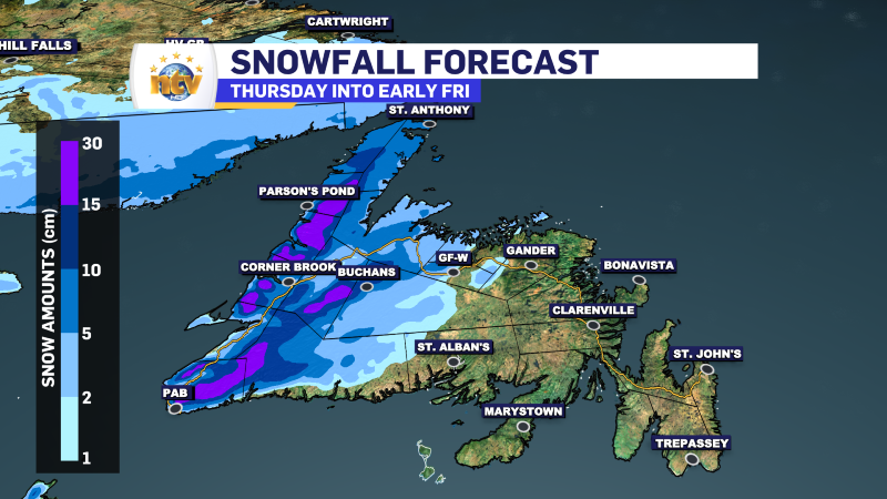
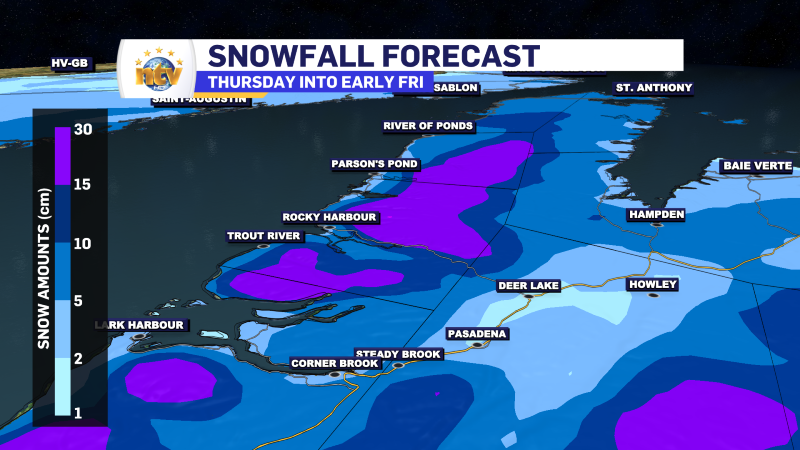
Expected snowfall: 15 to 30 cm. Locally higher amounts possible.
**EDDIE’S NOTE – my forecast may differ from this one and I think some areas of the Long Range Mountains may see more than 30 cm.. significantly so perhaps.**
Maximum wind gusts: north to northeasterly 80 to 100 km/h, strongest on Saturday night.
Locations: Gros Morne and the Great Northern Peninsula.
Similar storms in the past have led to:
– hazardous driving conditions
– delays and cancellations to ferry services
– scattered utility outages
Remarks: Heavy snow combined with strong winds will create widespread conditions of near-zero visibility in blowing snow. The snow may change to or mix with ice pellets over the Long Range Mountains and the eastern portion of the Great Northern Peninsula. Conditions are expected to improve by Sunday morning over most areas, but onshore flurries may persist through the day Sunday for areas along the Gulf of St. Lawrence.
Reevaluate plans for travel and outdoor activities this weekend. Rapidly accumulating snow and near-zero visibility will create dangerous conditions on roads and highways.
Winter storm watches are issued when multiple types of severe winter weather are expected to occur together.
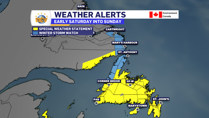
A Winter Storm Watch has been issued for the following areas in Labrador:
- Red Bay to L’Anse-au-Clair
- Norman Bay to Lodge Bay
- Cartwright to Black Tickle
Current details:
A significant winter storm, with the potential for blizzard conditions, is expected.
Time span: from midday Saturday into Sunday.
Expected snowfall: 20 to 30 cm. Locally higher amounts possible.
Maximum wind gusts: north to northeasterly 80 to 100 km/h, strongest on Saturday night.
Locations: southeastern Labrador.
Similar storms in the past have led to:
– delays and cancellations to ferry services
– closures of roads and highways
– scattered utility outages
Remarks: Heavy snow combined with strong winds will create blizzard-like conditions with near-zero visibility in blowing snow. Conditions are expected to improve by Sunday morning over southernmost areas, but snow and blowing snow may persist into Sunday afternoon from Black Tickle northward.
Reevaluate plans for travel and outdoor activities this weekend. Rapidly accumulating snow and near-zero visibility will create dangerous conditions on roads and highways.
Winter storm watches are issued when multiple types of severe winter weather are expected to occur together.
Get all alert details here.
POST 3 – 3:22 PM NST (2:52 PM AST)
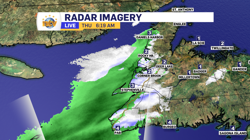
Roads across much of western Newfoundland are becoming snow covered at this hour due to the heavier snow moving into the area. This will ease in the next few hours as the snow moves out. Travel conditions will improve overnight once the snow ends.
Black Duck Siding
Corner Brook
Pynn’s Brook
Birchy Narrows
POST 2 – 12:46 PM NST (12:15 PM AST)
Big old snowflakes flying in Corner Brook this afternoon, but with temperatures just above freezing, not much seems to be sticking near Confederation Drive at this time. I suspect the higher elevations around the city look a bit more wintry.
I also just received a report on Facebook that rain is falling in Deer Lake, but as you head north on Route 430 you will run into the snow.
POST 1 – 6:14 AM NST (5:44 AM AST)
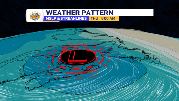
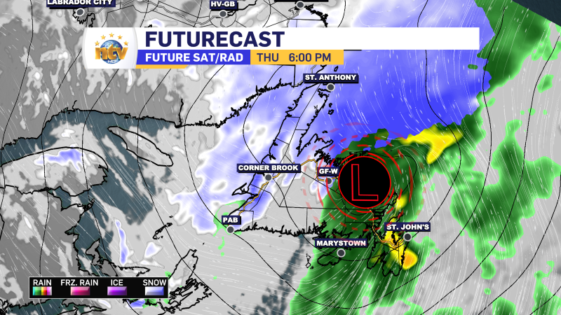
Rain arrived over western sections of the island this morning, except in the higher terrain, where snow is falling or there is a mix of rain and snow. The early AM radar image shows this well. The rain will spread east and north through the day as an area of low-pressure moves in.
Central areas will see this arrive later this morning, and the eastern third of the Island will see rain moving in this afternoon after a dry start to the day. The rain will be heavy at times this evening on the Avalon, which will make for an ugly commute.
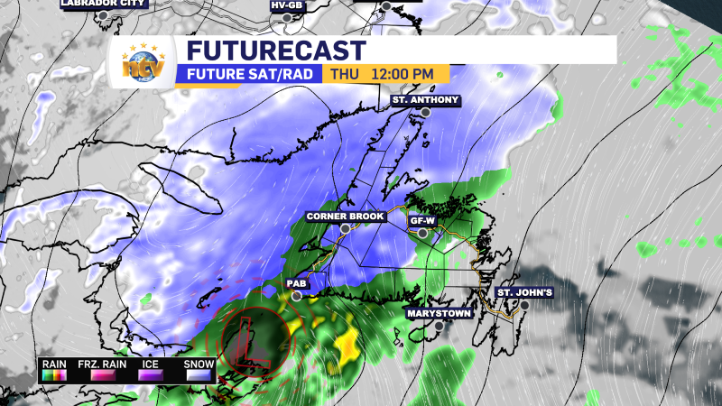
Snowfall today outside of the higher terrain will not be impressive. However, areas at the top of the Northern Peninsula will see wintry conditions, along with our neighbours on the other side of the Strait of Belle Isle.
Related Articles