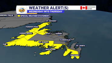
Wind and Snowfall Warnings are in effect for much of NL ahead of potent low

A potent area of low pressure will bring rain, snow and wind to the Province beginning later today and continuing into Friday. The ECCC NL Weather Office in Gander has issued multiple weather alerts ahead of the incoming system. They are listed below.
WIND WARNING | MAJORITY OF THE ISLAND
- Gusts of 80 to 100 km/h will be widespread, with some areas along the coast seeing gusts as high as 130 km/h.
- Time frame: This evening into nearly mid-day Friday
- Similar storms in the past have caused hazardous driving and disruptions to ferry services
- Avalon Peninsula North
- Avalon Peninsula Southeast
- Avalon Peninsula Southwest
- St. John’s and vicinity
- Avalon Peninsula Southwest
- Burin Peninsula
- Connaigre
- Bay of Exploits
- Bonavista North
- Bonavista Peninsula
- Burgeo – Ramea
- Clarenville and vicinity
- Gander and vicinity
- Green Bay – White Bay
- Terra Nova
- Northern Peninsula East
WIND WARNING | THE WEST COAST
- Gusts of 80 to 100 km/h, except as high as 150 km/h in areas prone to enhanced southeasterlies
- Time frame: This evening until late tonight or early Friday morning
- Corner Brook and vicinity
- Gros Morne
- Bay St. George
- Parson’s Pond – Hawke’s Bay
- Port Saunders and the Straits
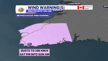
WIND WARNING | THE SOUTHWEST COAST
- Channel – Port aux Basques
- Gusts to 110 km/h
- Time span: this evening to the late tonight
- Wreckhouse Wind Warning
- Maximum southeasterly gusts to 150 km/h
- Winds increase with gusts to 90 km/h this afternoon, peaking this evening
WIND WARING | LABRADOR
- Maximum gusts 80 to 100 km/h
- Time span: Overnight into Friday morning
- Red Bay to L’anse-au-Clair
- Norman Bay to Lodge Bay
- Cartwright to Black Tickle
- Rigolet and vicinity
SNOWFALL WARNING | LABRADOR
- Time frame: Late tonight into Friday afternoon
- Rigolet and vicinity (5 -10 cm, except 15 over higher terrain)
- Postville – Makkovik (5 -10 cm, except 15 over higher terrain)
- Hopedale and vicinity (5 -10 cm, except 15 over higher terrain)
- Nain and vicinity (5 -10 cm, except 15 over higher terrain)
- Norman Bay to Lodge Bay (10-20 cm, up to 30 cm along higher terrain of TLH)
- Cartwright to Black Tickle (10-20 cm, up to 30 cm along higher terrain of TLH)
- Upper Lake Melville (10-20 cm, up to 30 cm along higher terrain of TLH)
- Eagle River (10-20 cm, up to 30 cm along higher terrain of TLH)
- Churchill Valley (10-20 cm, up to 30 cm along higher terrain of TLH)
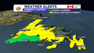
SNOWFALL WARNING | NEWFOUNDLAND
- Time frame: This evening into Friday morning
- Amounts: 5-10 cm, except 15 cm over higher terrain
- Highest amounts likely in the higher terrain around Corner Brook, the TCH, parts of Routes 410 and 430
- Corner Brook & vicinity
- Deer Lake – Humber Valley
- Gros Morne
- Buchans and the interior
- Green Bay – White Bay
EDDIE’S NOTES
Heavy rain will also fall over southern and eastern Newfoundland overnight into Friday morning. At this point, rainfall warnings don’t appear necessary. Areas of central and western Newfoundland will see snow overnight, which will change to rain from south to north Friday morning. Travel will be difficult at times tonight, especially inland over higher terrain. Driving conditions will improve Friday morning.
Friday afternoon will see snow squalls take hold over the West Coast, deteriorating driving conditions once again as some of the squalls will be locally intense.
Stay tuned for further details | Weather Alerts Below
Related Articles