Eddie’s Forecast: The weekend is looking a bit soggy!

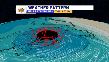
A cutoff low-pressure center is going to make itself very comfortable near Atlantic Canada this weekend. What is a cutoff low, you ask? A cutoff low is an area of low pressure that is “cut off” from the main upper air wind pattern or jet stream. The animation below shows the weather pattern we are going to be in this weekend.

The low is going to stall south of the Island, resulting in onshore, easterly flow and an influx of moisture, which will be realized in rainfall, some of which will be heavy.
These lows can bring multiple days of unsettled weather and yield high precipitation amounts. In this case, it looks like parts of Newfoundland are going to see a few days of rain, beginning later Saturday and continuing into Monday. Rainfall amounts will be highest over eastern and southeastern areas, where over 50 mm is possible in the 3-day span. The image below is the predicted rainfall from the RDPS model.

The Forecast
Monday
Another day of light to moderate is likely for eastern areas. However, this may be a day where east-facing shores take the brunt. Monday has the look of CBS being decent and East End being socked in and drizzly. Areas of Central, the South Coast, the West Coast, and GNP will see some sunny breaks at times. Highs of 9 east, 16 central, and 18 south and west.
Labrador will be mostly cloudy. Highs in the lower 20s.
Tuesday and Wednesday
It looks quiet across the region with less rain and less cloud cover. However, at this point, I don’t expect a drastic improvement in the weather. Highs on the Island will be in the teens to near 20 (coolest east), and highs in Larador will be in the lower to middle 20s.

Related Articles